


It was a cold morning as I made my way around Saddlebag Lake on the rocky trail. It had dropped below freezing the night before and there was an almost continual crunching sound with each step, either from frozen water, hard crunchy snow, or just the rocks grinding under foot on the trail. When I got to the backside of the lake I was greeted with reflections of Excelsior Peak and Shepherd's Crest shimmering in the far end of Saddlebag Lake. I stopped to take several photos, but little did I realize I had far better reflections in Greenstone Lake just ahead. I love being in the right place at the right time!


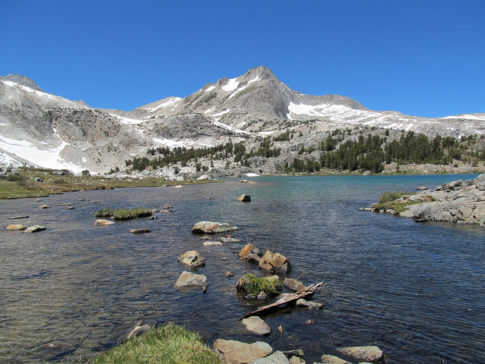
I was excited for the terrain after Greenstone Lake, because I would be visiting a new lake basin on the North side of North Peak. I also knew there were supposed to be stunning views of North Peak above the basin. It's famous snow/ice couloirs were clearly visible over here and my intended climb for the day - the NW ridge - made its first prominent appearance. The upper part of the ridge line took on a rather steep, menacing look from a couple angles. It looked like the ridge was leaning over at some awkward angle, ready to make anyone that attempted to scale it slide right off and plummet down to the glacier below. I knew things can often look worse from a distance, so I pressed ahead, hoping for more friendly views as I got closer. In the meantime, I enjoyed my walk around Steelhead Lake. Then, there was some friendly cross country around a few other unnamed smaller lakes and pretty mountain streams, while I soaked in the views of North Lake towering above the basin.


The ridge starts out easy enough, but one quickly comes to the first of several impasses, in the form of gaps in the ridge line. The first two were bypassed easily with some Class 3 climbing on either side of the ridge. The second one had a very enjoyable and somewhat tall section of Class 3, in order to regain the ridge. Atop this one, a better view of the remaining ridgeline comes into view and the path ahead starts to look a bit more serious. The upper part of the ridgeline comes back into view here, as well, and luckily starts to look a bit more friendly compared to the views from down in the Lake Basin. However, peering at the top of the route from this angle, one can start to see that the upper moves to exit the ridge are probably going to entail having a lot of air under one's ass! The route hugs the left side of the ridge line just above the cliffs dropping down to the glacier below.

I came to another impasse/gap in the ridge that was a made a bit tricky by some lingering snow. I wasn't sure how to get around it at first. It was too wide at the top to try and strech across to the other side and the snow was icy hard making traction difficult and standing on it rather dangerous. I finally found an easy, if somewhat circuitous, way around this part. The next section of ridge line was great, as it starts to sport dramatic drop-offs on either side. Despite the exposure and exciting aspect the ridge line was beginning to take, the climbing never got too difficult. There were even sections where I could simply walk across, even if rather gingerly. The setting was nothing short of stunning, with this long narrow ridge consisting of incredible views of Upper McCabe Lake on one side and the North Peak glacier on the other.
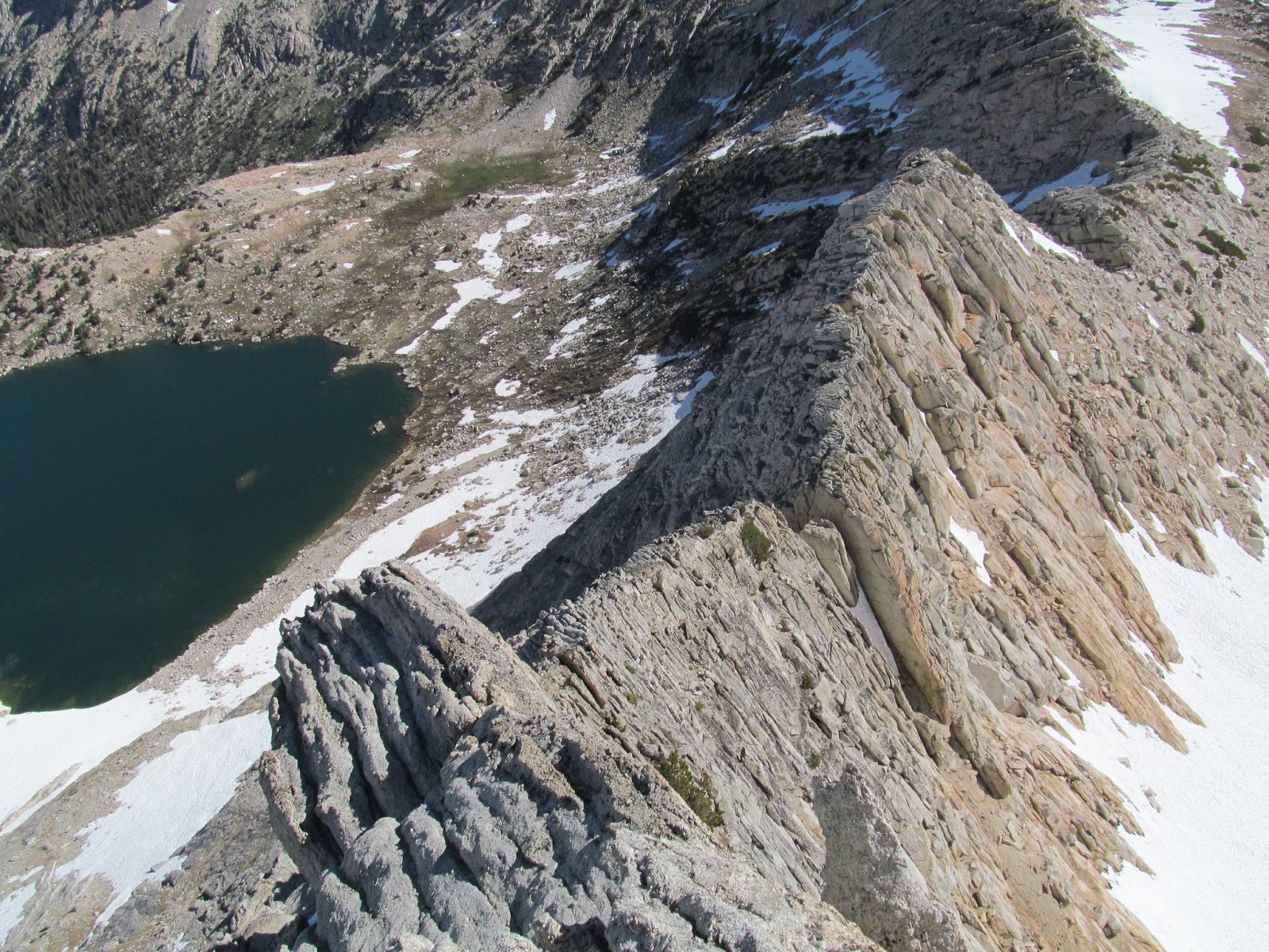
I eventually came to another impasse/gap that I think was made easier this time because of lingering snow. The top of the snow was flat and slightly melted, so I could stand on top of it and use it to reach the other side. Ultimately, I came to what is considered the crux of the route - the last and final gap in the ridge. The crux is a Class 5 downclimb into the notch. It seems most people bypass this crux, with an exposed 50+ foot Class 4 downclimb on the right side of the ridge line and then climbing back up the chute that leads into the gap. I put on the rock shoes at this point and gave the Class 5 downclimb a go. I thought this section was super fun and not really all that bad, leaving me to wonder why others avoid it. Climbing out of the gap on the other side seemed more exciting to me, which was odd since nobody ever mentions that. Once up and out of this last gap, the remaining part of the ridge line comes into view.

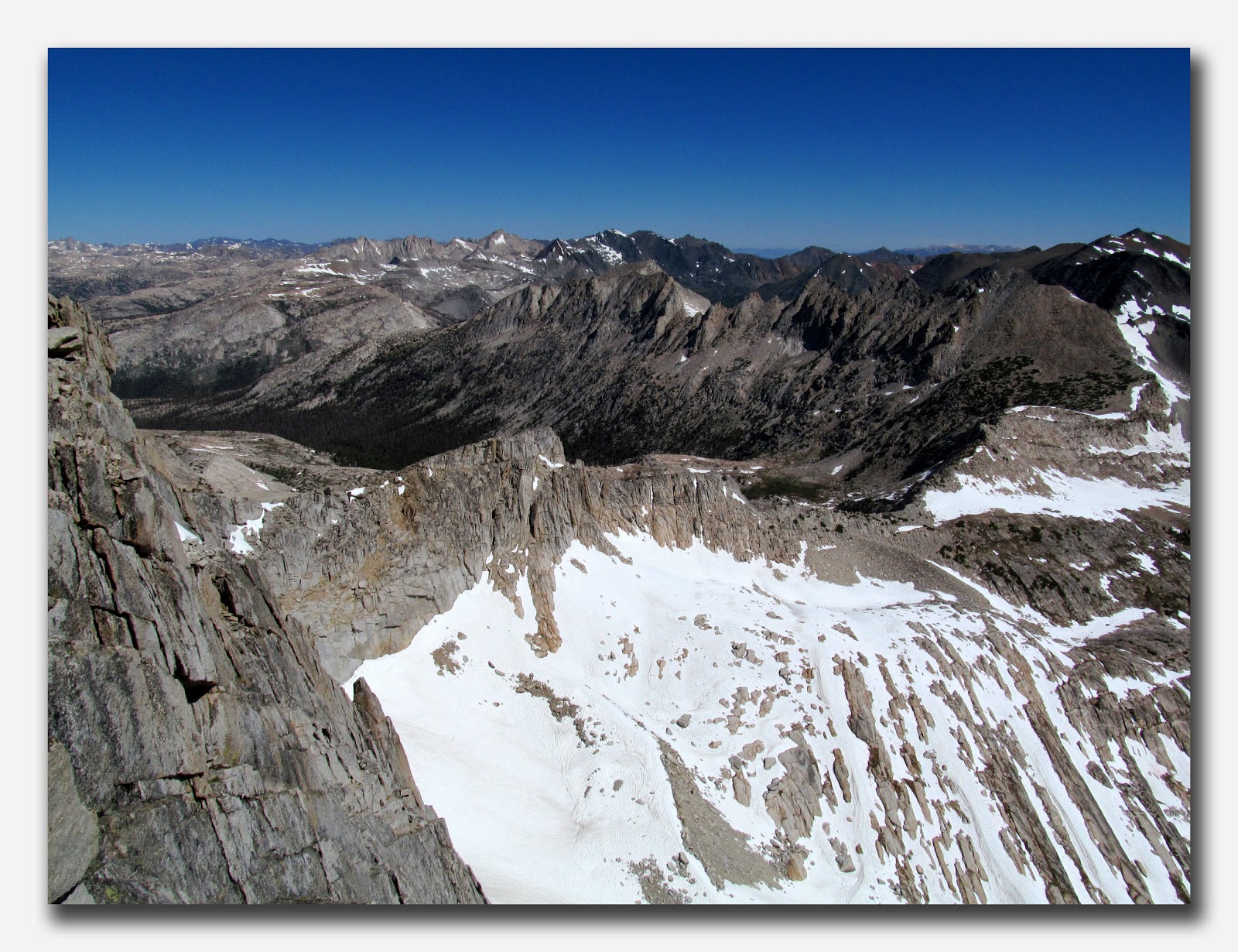
This section of the ridge is amazing. It starts out at a sustained Class 3, with an airy feel. Up higher, the climbing turns into a low Class 4, out on the face on the left side of the ridge. You climb up from one thin horizontal ledge to another, with a lot of air below you, which reaches all the way down to the glacier below. Eventually, you come to the last 15-20 feet, or so. From below, this looks harder than Class 4 and I still wouldn't argue if somebody wanted to call it low Class 5. From below, the great handholds one had to this point seem to be gone. The moves looked awfully commiting and I definitely vascillated a bit before starting up this part. I even tried peeking around the corner to see if I could avoid this section by finding an easier way up the back side, but no such luck. I mustered up a bit of courage and started up this last section. Each time one commits to the footholds and stands up, a good handhold, which was invisible from below, comes within reach. A few solid moves like this and you can reach up and grab the last big flake, which makes up the top of the ridge line. I clamored over the top and let out a little celebatory whoop. I soaked in the views, especially the one looking back down the ridgline. I can now see why this ridgeline is sometimes referred to as a Dragon's Spine. In the photo below you can also see the last gap/impasse, which is the generally accepted crux of the route.
There was still a bit of distance to go until arriving at the summit and it was a great workout. There was even some small sections of easy scrambling still left that were awfully fun. I eventually made it to the summit and soaked in the views. It was such a clear day with great views in every direction. I particularly enjoyed the view over towards Mount Conness, which looks truly impressive from this angle. I eyed the N ridge of that peak - a classic climb in the area. One day I would love to do that one too, but not that day, that's for sure. I was pretty beat at this point and I enjoyed a hard-earned snack. I took several photos of the clear summit views, with crystal clear blue skies and wide open mountain country in all directions.


I had one last worry before an easy and pleasant cruise back to the car. On the approach, I had noticed that the descent chutes visible on the Conness Lakes side of North Peak - my planned descent - were all covered in snow. I was pretty sure the slopes that were out of view were less steep and much less likely to be covered in snow, although it was no guarantee. Even if there was snow, it should be at a safe angle for descending without the use of ice axe and crampons. However, I was recollecting these slopes from 7-8 years prior and was unsure of current conditions. I started down from the summit, peering over the sides of the summit slopes and confirming that the descent chutes I saw on the way in were indeed steep and choked full of frozen snow still. No way I was going down those. When I came to the area I was most interested in descending, it was completely dry, indeed. In fact, it was a fairly pleasant descent, with either easy boulder hopping, or enjoyable boot-skiing down sections of scree and sand, while soaking in views of the partially frozen Conness Lakes below. These lakes look arctic at times, with their turquoise-blue color and pieces of shattered ice floating in them.
When I got down to the Lakes I had the pleasant surprise of running into Cori (a.k.a. the legendary snownymph) and her friend Karen. First time meeting either of them and they were very friendly. We talked for a while about the mountains, cameras and similar topics, before I started the rest of the way down. I love this side of North Peak, otherwise known as the Conness Lakes basin. After the lakes, it's waterfalls, gurgling streams, green meadows and wildflowers, until one finally gets back to Greenstone Lake, thereby completing the loop. I had run out of water a ways back and was pretty parched. It was a warm dry jaunt back around Saddlebag Lake, before arriving back at the trail head and the cold refreshing Sierra Nevada Summer-fest Ale's waiting for me in the car.
Feeling very grateful for an awesome day in the Sierra!

I also had my GoPro camera along for the climb. First time out with it in the mountains and it took surprisingly good video. It definitely still seems more fitting for use with dirt biking, but I think I may take it along on a Sierra trip every now and then. The video below gives a decent feel for what much of the climb was like.
North Peak, NW Ridge H.264 from Evan and Rebecca Thomas on Vimeo.
No comments:
Post a Comment