"The most beautiful thing we can experience is the mysterious" ~ Albert Einstein

Topics

Showing posts with label Desert. Show all posts

Wednesday, January 14, 2015

Avawatz Mountain and McCullough Mountain

Much like us, mountains often seem to have personalities.  At the very least, each mountain has its own distinctive feel, with there being a veritably infinite set of variations amongst the mountains out there.  Sounds crazy, but it seems like many people who spend some time in the mountains, come away saying something similar.  But, have you ever had that experience where you see somebody in photos, or hear about a person through third parties, but when you finally meet them in person, they seem quite different from what you expected and built up in your mind.   More rarely, some folks turn out to be almost exactly what you expected.  Over the Christmas break, I went on a road trip that involved hiking two different desert peaks - Avawatz Mountain outside Baker, California and McCullough Mountain just over the border in Nevada - that were fine examples of both scenarios.


Avawatz turned out to be different than what I had expected for a few reasons, starting with the drive in to the “trailhead”.  The guidebook talks about what sounds to be an easy-to-reach 2wd trailhead and a 4wd trailhead that is further in.  The 2wd trailhead is at the base of the mountains at what's called Mormon Springs.  The hike from there is around 13 miles rough trip and perhaps close to 4,000 feet of gain.  Depending on how far you can make it up the 4wd road section, the hike could be as short as six miles round trip, with considerably less gain.  Well, apparently, things have changed since the guide book was written.  In fact, based on other reports I have read, something must have changed in the past couple years.  The 4wd road was gone.  And, I mean gone, like obliterated, an apparent victim of flash flooding, which left only a rutted out wash instead, with no trace of the old road remaining.  Even the 2wd road was rougher than anticipated and one section stymied me on two attempts in my 4wd 4runner.  I could have probably eventually made it through, even with my balding tires, but I get nervous with stuff like that when I am solo, so I ended up parking about a mile shy of the 2wd parking, making for a 15 mile day and roughly 5000' of gain. 


All this turned out to be advantageous when it came to the photography, though.  As I started out for the peak in the morning, a little ways down in the desert was THE place to be, as the sun came out for a beautiful sunrise light-show.  The morning lighting was so moody and colorful and the hillsides of Avawatz Mountains were also briefly lit up with wonderful, pastel-like hues of color.  After roughly a mile of soaking in this amazing light, I entered the canyon leading into the mountains.  This timing was perfect because the sky and lighting got pretty bleak once the sunrise was over.   Although the canyon portion wasn’t the mindless, easy stroll up a road I was expecting, it was still rather pleasant, albeit a bit more tiring.  Some parts of the wash were a bit messy and rough, but many stretches were sandy and pleasant enough.  I love the feelings of these desert canyons at times.  They seem like a magical place - focal points for the mysterious energy of the desert.  Sometimes, I swear you can almost feel a timeless, serene energy reverberating off the canyon walls, especially so when they are glowing golden in a late afternoon light.  What I guess was a raven, maybe a hawk, would occasionally fly by, squawking over me with that classic sound you often hear in a movie with a desert scene.  It's mysterious call would echo off the canyon walls.  It reminded me of that scene in the The Doors movie when Morrison wanders off in the desert, minus the hallucinations since I wasn’t on Peyote myself.  


After a few miles in the canyon, I found myself at the small, abandoned radio tower of sorts along the ridge.  Shortly before this spot, I was able to pick the old road back up where it climbs out of the canyon putting a safe distance between itself and the flash flooding below.  From the tower, I followed the road as it contoured around to the hillsides on the far side.  I picked a semi-random spot to leave the road and gain the ridgeline, but not before meeting the crux of the route.  This consists of a steep hillside with white cliffs, which was now towering in front of me.  It mostly looked like it would be a bit tiring, but I could see obvious ways around the cliffs, so I wasn’t too worried about them.  In fact, it wasn’t too bad overall.  I just took my time and next thing I knew I was on top and starting out along the ridgeline to Avawatz.  This portion was pretty long too, but I had some amazing clouds to gaze at and occupy my mind as I strolled along.  The clouds looked surreal: popcorn shaped puffs, forming checkerboard like patterns off to the horizon in both directions.  I was lucky to have these clouds spice up an otherwise bleak, gray sky.  In addition, the timing of my arrival at the summit was rather fortuitous, in that all the clouds and bleak lighting I had since after sunrise, mostly cleared up right after I got there, leaving me crisp, clear vistas with just the right amount of clouds to spice up the view.  Some of the remaining popcorn-puff clouds left a checkerboard like pattern of shadows across the desert floor to the East.   I rested for some time, took photos, snacked and soaked in the views as much as I could before starting down.  Most of the hike back down was uneventful.  I enjoyed snapping photos of the hillsides on the way down, which were now vibrant and colorful with the bright, clear afternoon light.  When I got back to the car, I enjoyed a beer and relaxed in the back of the 4runner cooking up some dinner – black bean soup with a can of chicken thrown in.  A pretty tasty meal for a hungry hiker.  After dinner I packed up all my stuff and slowly made my way down the rough road and on to McCullough Mountain.


McCullough Mountain turned out to be almost exactly what I expected and built up on my mind.  Right from the drive in, McCullough felt a bit familiar, despite never having the pleasure of meeting this mountain in person before.  There was roughly eight miles of dirt road to get to the start of the hike near Pine Springs.  
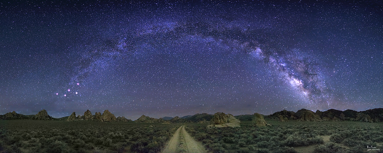
This road was in considerably better condition than the road to Avawatz and the miles went by quickly.  There were still some rough spots, but at least I could get above 10 mph quite often, unlike with Avawatz where I felt like my speedometer was on zero most of the time.  I took a few night sky photos on the way in, but between it not being the season for Milky Way photos and the moon being out I had a hard time getting a nice photograph of our galaxy.  Still though, I did get one, or two, of the dirt road and Joshua trees with a nice star-covered sky.  With it already being dark and my long hike earlier in the day, I retired to the back of the 4Runner for a good night’s sleep shortly after I arrived.


It was awfully cold when I started the hike to McCullough the next morning.  It was the kind of cold where I felt like I had to keep moving just to avoid going hypothermic.  I tried to stop and take a few photos of the morning light as the sun began to rise, but my fingers were stinging and going numb almost instantly, accompanied by rather intense shivering.  All this initially made photography a particularly unpleasant activity, resulting in only a couple photos of marginal quality.  But, once that sun started to rise, it warmed up really, really fast and next thing I knew I was removing a few layers.


McCullough has a reputation of being a navigation, or orienteering, challenge and right from the start I could tell it would live up to this reputation.  It’s not even real obvious you are hiking into actual mountains in the beginning, let alone having a visible summit, or high point, you can aim for.  Initially, McCullough is hidden behind an intervening ridgeline covered in many similar looking hill tops, or high points.  Really, it looks like you’re just hiking into a jumble of bushy, desert hillsides, with all directions looking the same.  There are many washes to choose from and no real clear high point of reference that makes one more appealing to take than the other, in so far as being sure it’s taking you in a direction towards the actual highpoint of the range.  A topo map and compass would make all this easier, but even that would be challenging.  Luckily, I cheated and downloaded a pre-planned route I came up with into my GPS and mindlessly followed that to the top.  Although, having my GPS fail on me more than once before when I needed it, I was at least smart enough to vigilantly make note of my surroundings in case I had to hike back without any electronic assistance. 


Overall, the hike was very pleasant, much of which involved hiking up sandy tree-lined washes while being bathed in the warm, golden early-morning sunlight and listening to birds chirp some morning song.  Apparently, the mountain is extremely popular with cows, as there were cattle tracks all over often forming a clear herd path.  At first, I thought of the old saying, “follow the cows home”, in the event that my GPS actually did die, but it soon became clear cows had been up and down every canyon I came across, leaving there tracks unhelpful in choosing which way to go.  Maybe all the tracks were a result of them getting lost in this maze of pine, creosote and sage.  It didn't take long to get to the summit and I think I was on top before 9AM, enjoying the views off into every direction.  I could see Las Vegas peeking out behind some intervening hillsides.  It sure looked tiny from my comparatively lofty vantage point.  I could also see the massive solar power plant near state-line.  Not too long into my stay I heard some cows that were making quite a racket down in the canyon I had just hiked up.  On my way down, I noticed that it looked like a family consisting of an adult female, two calves and an ever-watchful bull that let me know I better steer (no pun-intended) clear as he let out some loud bellows that echoed across the canyon. When I finally made eye-contact with him, he reminded me of a neighbor’s dog back home who would always give the obligatory warning barks, but you could tell by the look in his eye and the energy he gave off that he was relaxed with no real desire to come after you.  He just had to do what a guard dog is supposed to do, that is, bark at strangers.  Likewise with this Bull.  But I kept to the far side of the canyon to be safe, which suddenly didn’t seem as wide as it did before.  Maybe I made more of a big deal out of this than I needed to, but tank-sized animals with large horns making loud bellowing noises always make me a little nervous. 


I had a nice lunch along the crest of the intervening ridgeline that was about halfway between my car and the summit.  However, I wasn’t sitting quite where I thought I was sitting.  Turns out that section of ridgeline looked just like a saddle I still needed to cross over to get into the correct wash that heads back to my car.  So, even with the GPS in hand, I still managed to not traverse over to the saddle like I should have, instead dropping down too early and heading down the entirely wrong canyon!  Luckily I caught my mistake after not too long, but it still left me with an extra couple hundred feet of hillside I had to now climb back up, so I could cross back over into the correct canyon.  Consulting a topo map later on, I noticed the canyon I took by accident would have taken me pretty far from my car if I had not caught my error.  I would have found myself standing at the foothills of the McCullough Mountain range with over a mile of intervening ridgelines and washes between me and my car and wondering where the hell I was.  But, luckily that didn’t happen and I arrived back at my car for a celebratory beer to toast off a couple of nice, adventurous days in the desert.


Sunday, June 1, 2014

New Photography Websites

Hello, I have to apologize that it's been so long since I put up a new blog post.  I've been dedicating most of my spare time to starting up a new photography hobby on the side.  I've started a couple new websites and have been taking several trips to feed my new obsession with the Milky Way.

If you like the photos below, you can see more here:

https://www.facebook.com/evanthomasphoto

http://www.evanthomasphoto.com/

Feel free to like and share on facebook.  I'd be eternally grateful for any help on getting the word out.

I still managed to get two new blog posts about 98% done that I will be posting up soon.  One of them is about Time Symmetric Quantum Mechanics, which offers an answer to Einstein's question on why God would play dice with the Universe.  In the other I decided to tackle the meaning of life ... easy one, right?

Hope folks enjoy the photos in the meantime.


Saturday, February 22, 2014

Helter Skelter in Death Valley, December 2013

On the weekend before Christmas week, I decided to head out to Death Valley.  The only thing feeling more haphazard, disorderly and confused than me on this trip was the weather.  I felt scatter brained from the start.  It seemed like I was constantly fumbling with gear I couldn't find, or forgot altogether.  Not only could I not decide on what to do and where to go, I would ultimately fail to reach the destinations I finally picked.  Still, I enjoyed riding the whirlwind, which ultimately purged me of my stresses and scatter-brained tensions, allowing me to relax into the next two and a half weeks I had off.

For one of the sunniest places on Earth, the skies and lighting could not have been more dismal over Death Valley.  But, the sun would not give up, momentarily breaking through the gloom now and then.  Likewise, with the stars.  I tried to take photographic advantage of each moment.  Rain clouds tried to form, dropping a few drops and the occasional odd thunder peel could be heard on the horizon on the first day.  After a sunny hike in the morning on the second day, I drove through a snow squall on the way back home over Towne Pass and all around Darwin.

On the drive there, I saw some wild Burros along the 190.  They were quite the jittery pair, so they ran pretty far once they spotted me.  I thought maybe they were the same jittery guys I saw a couple months back along the beginning of the nearby Saline Valley Road, but with one of their companions now missing.  Anyhow, add the distance to the dismal lighting and I didn't get the best photo.  Still, I always love a wildlife sighting.


As I already hinted at, I didn't know where to go when I first arrived.  The crappy weather had me all thrown off.  I ended up parking by Corkscrew Peak and just wandering aimlessly in the desert.  An interesting peak eventually caught my eye that I figured must be Little Corkscrew Peak.  I decided to give it a go, or more correctly, I was pulled inexorably in its direction like sailors were towards the sirens in the old Greek legends.  Perhaps, not an altogether bad comparison, either.  Although, I was not crashed to death up against rocks, I was repeatedly cliffed out trying to get to the top, as I "corkscrewed" around the West side of the Little Corkscrew Peak several times.  I finally realized what side I needed to be on.  With the heavy pack full of my photography gear and my ankle acting up a bit, I decided to save it for another time.  I wandered over to a nearby easier peak by following big horn sheep trails which were occasionally littered with their droppings.  Since the peak did not have a register, nor was it named on the map, I took the liberty of unofficially naming it Sheep Poop Peak.  The next picture shows Little Corkscrew Peak above the wash I used on approach to the saddle found on the west side of the peak.


Afterwards, I headed up to Dante's View where I decided to spend the night in my car, taking pictures of the night sky before going to bed and hoping for some sunrise shots in the morning.  Neither quite worked out as planned - cloudy skies at night, which somehow amazingly cleared right before sunrise.  Still, I managed to get a few fun images. The first is a 30 sec exposure which caught a sunset afterglow no longer visible to the naked eye, as well as adding a cool effect by smearing out the clouds.  Just wish the stars were in better focus.  The next image shows the Milky Way and Venus momentarily popping out from behind the clouds.  The third is from a failed timelapse of the moon, but I still managed to grab that image out of it.


I also tried my telephoto lens out for the first time on the moon.  I was pleasantly surprised by how much detail it caught.  The following is a crop of a 300mm focal length shot.  I am excited to try more moonshots, with either something interesting in the foreground, or during a moonrise in the east while the moon is buried in the pastel colors shortly after a sunset.


Since the sunset fizzled the following morning, I ended up taking more pictures of the moon as it set into an ocean of clouds above the Panamint Range.  I was surprised by the wide range of camera settings (shutter and aperture) needed to properly expose the moon in different conditions.  Get it wrong and no details of its surface show up.  I definitely still need some practice.

For day 2, I decided to try and find the "secret" Kaleidoscope Canyon, since it was supposed to be a great spot for photography.  The canyon walls are apparently covered in rocks of various colors similar to Artists Pallet.   Since the sun managed to peak out during the morning, I figured conditions might even be good for capturing the colors.

On the way to the Canyon, I came across the Time Traveling Gypsy Mobile at Death Valley Junction.  I seriously thought about trading in the 4Runner for this thing.


Kaleidoscope Canyon is called "secret" because guidebook authors have left it out of their books for now and folks who have managed to find it have, so far, stayed mum on the location.  I gathered a few vague hints on where it might be, studied the map, picked a potential canyon and loaded it into my GPS.  After hiking up the initial wash for two miles, I was about to turn into the canyon (then, still out of sight) I suspected was the correct spot.  As I turned the corner, I found .... nothing!  I was a bit shocked I had guessed wrong, so I guess my over-confidence was a bit unwarranted.  I decided to try the right branch to this canyon, as well, but as I came around each turn I was greeted with another view that looked nothing like the impressive Kaleidoscope was supposed to look.  I felt like I was getting sucked further and further back into the mountains as they kept showing me something around the next corner that tantalizingly looked like it might be the location of Kaleidoscope canyon but, in reality, was not.  I decided to stop playing the mountains games and I eventually gave up and turned around.  Besides, it was supposed to be found much closer to the road than I was at that point.  It was still a great hike in a pretty area with lots of solitude, though.  I'm cautiously optimistic I know where the canyon is for next time! 

I ran into this cute little guy on the way back to the car.  He also wouldn't let me photograph his little "secret" - the vibrantly colored topside of his wings.  Apparently, when threatened these butterflies pinch their wings together, revealing only the bottom sides, which blend perfectly into the surrounding rocks.  Seems like the desert often tries to hide its colors, but it can be quite a beautiful sight when it finally reveals them.  You just have to be lucky enough to be there with your camera in the right place at the right time.  I hope I have a little more luck on the next trip!


I could tell I was a little out of shape, because the hike sure made me tired, but it felt great to get the needed exercise. After relaxing by the car and enjoying a beer, I started to drive back up towards Bad Water along the southern end of the park.  Near Jubilee Pass the sun struggled to break through the clouds again, finally succeeding as I got down to the valley floor. 


I saw several coyotes one other time while coming through here. On the off chance that I would see them again, I grabbed my telephoto lens and got it ready.  Sure enough a couple coyotes were hanging out along side the road in what seemed like the same spot as last time, or at least very close to it.  One of the coyotes was not very shy and would get fairly close to my car.  His companion was more shy and hung out by the bushes some distance a way.  It was pretty obvious they were looking for food handouts, which I resisted giving them.


Once again, the weather couldn't make up its mind and the drive home over Towne Pass and the next pass to the West near Darwin had me driving in the snow.  I got out to take a quick picture at Towne Pass and discovered that the temperate had sure plummeted, brrrrrr.


A great trip, overall.  Check out the rest of my photos on SmugMug.

Wednesday, February 12, 2014

Spirit Mountain (5,639'), Nevada, January 18th, 2014

The weekend of January 18th, 2013 had me once again setting off for another remote corner of the desert. The original plan was to head out to Searchlight, Nevada and climb nearby Spirit Mountain, which is about (10² + 8²)^(½) miles from Searchlight, as the crow flies, using the Pythagorean Theorem and the fact that one drives south for 10 miles on the 93 before driving east for 8 miles on a dirt road slightly past Christmas Tree Pass to the starting point for Spirit Mountain.  (Yes, this is occasionally a math/physics blogs too)  The following day I would climb New York Mountain in Mojave National Preserve.  In the end, I was pretty beat after Spirit for some reason, so I tucked my tail between my legs and headed home a day early.  Still, I felt quite satisfied, for Spirit Mountain was a great experience.

The drive out to Searchlight had me on the Joshua Tree Highway in Nevada.  I couldn't see most of the surroundings which were swallowed up in the blackness of night.  Except for a few sections, which had the unmistakable, contorted silhouettes of Joshua Trees, looking like they were reaching out over the highway, as if they were almost trying to grab my vehicle.  I blinked and almost missed the entire town of Nipton, CA, which is a place I recommend for filming the next Texas Chainsaw Massacre.  Searchlight, NV itself was more than a few blinks of the eye long, but I quickly put that town behind me and was once again heading in earnest across the desert.

I was pleased to find the dirt road heading to Spirit was in excellent shape.  While driving over Christmas Tree Pass, I noticed the Junipers and Yuccas were actually decorated with tinsel and Christmas ornaments here. This gave me the creeps a bit in the dark, as I pictured some desert loons running around in the middle of nowhere with Christmas decorations, but I appreciated the fun, festive, harmless nature of it later the next day.  I finally arrived at Christmas Tree pass a bit after 11PM and crashed in my car for the night, falling asleep to the wind blowing over the pass. I woke up the next morning to a nice scene of the moon setting while the sunrise lit up the nearby hillsides.


The hike starts out for a very short distance on a dirt road, but the route quickly turns into cross country and heads to a small saddle not far from the trail head.  The peaceful, beautiful ambiance of the mountain was obvious from the start.  In fact, this mountain is a sacred place to the Chemehuevi Indians.  I don't know exactly why, maybe proximity, or local history, or the fact that the peak looks like it is covered in granite steeples, but just the feeling of the place has to factor in somewhere.  Along this initial section were some of the healthiest and robust looking chollas I've ever seen all in one place.  I was sure it was going to be a cactus-jumping fest to get up the peak, but it was as if a heavenly truce was set up between man and cactus here on this sacred mountain.  Or, maybe it was just the small use trail one soon encounters near the base, which avoided the cacti by weaving around and past them.  There were also some nice looking barrel cactus along this stretch.  These barrel cactus had a distinctive purple color in the morning shade, but looked bright red later in the day, when the long shadow of Spirit mountain finally retreated under the advance of the noonday sun and allowed daylight to reach the ground here.


The use trail leads to a tiny saddle between a small tower and the main massif of Spirit Mountain.  From here, one traverses over into the main ascent gully used to get up Spirit by most parties.  The use trail was fairly solid throughout this section making for considerably easier travel than it would be without it.  Still, the going was steep, gaining a couple thousand feet in around a mile.  Some Class 2 scrambling was required in a couple sections in addition to the occasional wrestling match with a few bushes.  The use trail wasn't perfect either, so I did manage to lose it for a few brief periods.  As I climbed higher between granite spires some expansive nice views opened up off to the West.


After trudging up the main ascent gully, I reached the summit ridge itself where a short jaunt leads to the summit area of Spirit Mountain.  Of course, being on sacred ground, something had to be guarding the summit, which took its shape in the form of a Class 3 section that needed to be surmounted. 


This was easy enough to climb and I soon found myself on the summit.  The views were expansive and I'm pretty sure the photos just don't do it justice.  I humped all my photography gear up there so I had fun playing around with the tripod and taking some panoramas.  Those can be seen on our smugmug page (social media button above), but here are a few photos of the summit views.  


I also wandered over the lower eastern summit to take in views of Lake Mojave down below.  I spent probably a good hour up there soaking it all in before slowly making my way back down.  Overall the descent was uneventful.  I eventually made my way back down to the tiny saddle behind the small tower near the bottom.   The granite spires were all lit in the daylight now and looked beautiful.  It seemed like a perfect place to rest and have a bite to eat.  I was cozy for about 2 minutes before a bee decided to come along and harass me.  I finished my food pacing around a bit since this little guy wouldn't stay out of my face. I took one last look over towards the granite spires and continued down the use trail with the occasional behemoth barrel cactus and rock cairn marking the way.


On the last little stretch I saw a few big jack rabbits hop away as I walked past the bushes they were hiding in.  I relaxed in the back of the 4Runner and enjoyed a couple Hop Notch IPAs from Uinta Brewery my brother-in-law gave us while we were back in Utah for Christmas.  I thought I would try and get a few photos of the rabbits before I left, but now that I had my telephoto out they were all gone.  Considering it was a 3-4 hour drive back home, it sure went by fast.  Great trip!


Wednesday, November 20, 2013

Blackrock Well Petroglyphs and Lee Flat Nightscapes, November 9th, 2013

On the east side of Lee Flat and up against the western flank of Nelson Mountain range, lies Blackrock Well - a place where one can take a walk back through time.  This is a remote, secluded petroglyph site where ancient drawings on the canyon rocks tell stories from people long ago.  I had tried to get to this site on my Lee Flat, Darwin Plateau Exploration ride a few weeks back, but had bungled the directions, ending up a not-so-impressive old mining site instead.  Disappointed to miss the petroglphys, I came back out over the weekend of November 9th, 2013, with Rebecca and the doggies, Rosco and Daisy, for a second attempt at locating this magical little canyon.

Doing a little more research this time, I realized there was no road to the actual location.  Perfect!  It had been a while since my last hike and it felt great to get out again.  Plus, I knew the site would be that much more secluded.  It was about 2 miles of cross country travel through scattered Joshua Trees across Lee Flat, leading to the western escarpment of the Nelson range.  Canyons wind their way down from the high rocky ridges, with dark, volcanic looking rocks gathered near the bottom flanks.  One of these canyons had the mysterious petroglyhs we were looking for.  But, which one?


Showing up extra prepared this time, we used a GPS to lead us right to the canyon holding Blackrock Well and its rock art.  It would have been easy to spot, but I wasn't taking any chances this time!  There was one particular canyon where Mother Nature had gathered the areas prize collection of dark-colored, clean, granitic boulders that native people discovered made a perfect parchment for their artwork.  The drawings are enigmatic and one can't help but wonder what story they are trying to tell, but the details are lost to time.  However, some things were clear.  Big Horn Sheep and the Snake were obvious co-inhabitants in this land long ago, as they figured prominently in many of the drawings.  Occasionally a figure of either a warrior, or hunter, would appear.  Sun bursts would appear, giving hints the desert could get just as hot then, as now.


After taking an extended hike further up-canyon and taking lots of photographs, we trekked back across Lee Flat, hopped in the 4Runner and headed over to the excellent camp site I found last time I was here.  Rebeca made a yummy back country dinner, which you can read about here.  It was delicious!  The dogs were so relaxed, as they hung out nearby in the vehicle.  They had the most amazing expressions of serene contentment I had ever seen.  Clearly, they needed a good hike too!

Next up, waiting, followed by a little more waiting.  We didn't mind.  It always feels nice to soak in the desert surroundings.  We were waiting to try out some timelapse photography on the sunset, followed my some photos of the night sky.  The sunset wasn't spectacular, but the timelapse still came out pretty decent.  The clouds were very cool.  They appeared stationary in real time, so it was neat to see all the hidden movement come alive in the video!  I also took an hour's worth of exposures every 60 secs to put together one of my first star trails photo and an accompanying timelapse.  I didn't get the intervals quite short enough, though.  So, overall, nothing spectacular, but good stuff for a first try.


Lee Flat Sunset

Orion Rising

Cosmic Spin Cycle

Our timelapse vidoes are available on Vimeo and embedded below.


We just ordered a new dSLR, which should really improve the landscape and night scape photos.  A Canon EOS 6D with a Sigma 20mm f/1.8 Wide Angle lens.  Cant' wait to try it out on an upcoming trip!

I think we got hooked on the petroglphys too.  There are many other secluded sites in Death Valley that are not well known and would also be very cool to visit.  So much to explore!

Smugmug Photo Album - Blackrock Well Petroglyphs, Lee Flat Sunset n Nightscapes