"The most beautiful thing we can experience is the mysterious" ~ Albert Einstein

Topics

Showing posts with label Dirt Biking. Show all posts

Friday, October 25, 2013

Inyo Mountains, Mazourka Canyon Ride, May 25th, 2012

This is another one of those retrospective blog posts. Since I've been writing up trip reports on a few recent outings, it seems like a shame to not have one for some of our more noteworthy trips in the past.  Plus, I wanted this blog to partly be a resource for others to find inspiring, fun destinations to explore and ideas for adventure.  Not too mention, on this particular trip, I made one of my first GoPro videos that actually turned out half-way decent!  Curtis and Mark joined me on this trip.

Our ride went up Mazourka Canyon and into the Inyo Mountains.  Inyo comes from the Owens Valley Paiute, which means "dwelling place of the Great Spirit".*  We slowly made our way up Mazourka Canyon and entered Badger Flats, without much anticipation of an actual meeting along the lines of Moses' encounter on Mount Sinai.  From Badger Flats, we started a loop that initially heads back towards Papoose Flats.  This section of road got a little rocky and rough in places, but it was a lot of fun and the views off to the Sierra were pretty expansive in several spots.  Papoose Flats was a really cool place - remote, scenic and tad-bit unusual.  It's a fairly wide flat with large, isolated granitic boulder formations spread out across its extent, which had a somewhat other-worldly feel to them.  If it wasn't for all the sage and other desert brush, which makes me feel right at home, Papoose could almost start to resemble an alien landscape. 


Papoose Flats

Papoose Flats
We had lunch in Papoose Flats before heading over to Squaw Flats, another pretty and isolated area nestled deep in the Inyos.  The trail was pretty sandy getting over to Squaw, but then there was a fast, fun section of trail right through Squaw Flats that led to a hill climb of sorts on the far side.  I had a blast trying to keep up with Curtis through this part as we weaved our way along to the far side of Squaw Flat.  However, it made it go by too fast!  It was nice to visit Squaw Flats again because it brought back some good memories.  Rebecca and I drove back there quite a few years ago to hike up Waucoba Peak and Squaw Peak with Rosco and Daisy.  We all really enjoyed that one.  Gotta say, sure was a lot easier getting back there on a dirt bike, though!

From here, we headed out to the 178 highway and then circled back through Harkless Flats before returning to Papoose Flats.  I'd love to get back to Harkless Flats to explore around some more.  The crest between Papoose and Harkless had yet more great views of Owens Valley and the Sierra.  The clouds were building above the Sierra by this point and a swift wind was picking up over the Inyos.


Looking Back At Squaw Flats


When we got back to Badger Flats near the top of Mazourka Canyon road, Curtis and Mark had to head back home to Ridgecrest and take care of some family business.  Since I drove up separate, I decided to stay and ride on up to the top of Mazourka Peak and check out the views, which held some promise for being some of the best that day and, indeed, they certainly were.  I found a couple of really nice on-the-edge-of-the-world camp sites up there that are still on the to-do list for one day!  I got off my bike, took off the helmet and some gear and relaxed for a while in this awe-inspiring location.  I love crisp, cold mountain winds.  They feel almost cathartic and enlivening as they purify, carrying away any concerns, frustrations, or any other emotional tensions, with each gust.  I rode back down the mountain feeling re-invigorated.

Next up, I decided to try getting out to the Betty Jumbo Mine, one of those more obscure locales.  The road to Betty Jumbo follows a narrow road that precipitously snakes its way along the side of the Inyos for about 9 miles, with a lot of steep, rugged mountainside stretching far above on one side and far below on the other.  Frequent large, fallen boulders lay across the middle of the road.  It's always neat getting to these antiquated, rarely-visited old mining sites. Since the mine site was separated off a bit from the main mountain massif and out on an isolated sub-peak, it made for a nice lookout with views stretching up and down Owens Valley below.  One can quickly feel tiny and insignificant in this vast landscape.


Betty Jumbo Mine
Looking Back At Road to Betty Jumbo
Betty Jumbo Mine

I slowly made my way back over to Mazourka Canyon and down to my vehicle parked in Owens Valley.  I packed up my gear and loaded my bike up as the wind occasionally blasted me with clouds of sand swept up from the desert floor.  I headed back down the 395 to a hot shower, a yummy dinner and a couple cold beers.  After a good night sleep, I enjoyed relaxing the next day.  I always enjoy the contrast of rugged adventure, followed by a well-earned day of sheer, utter laziness.  ;-)


*Zdon, Andy; Desert Summits, Spotted Dog Press, 2000

Wednesday, October 16, 2013

Lee Flat, Darwin Plateau Exploration, October 12th, 2013

'''Be ye warned, 'dem Flats be haunted with the restless, angry ghosts of old-time Death Valley miners".   That's along the lines of what some enigmatic Internet personality named Dingus Milktoast once dramatically told me about Lee Flat - a semi-remote spot in Death Valley NP, which also happens to be one of the more impressive Joshua Tree "forests" in California.  I don't know if that factored into my decision on whether to drive out the night before my ride and spend the night in Lee Flat or leave really early in the morning instead, but I ended up going with the early morning departure.

When I arrived to the turn off for Lee Flat the next morning, Wild Burros were hanging out in the area.  Most burros I have seen in the past either barely take the time to look up and acknowledge your presence, or they just stand there and keep a leery eye on you until you leave.  These three guys were jittery and booked it quite a ways before finally turning around and staring me down with much trepidation.  Between that, the low light and incorrect camera settings, I didn't get the best picture.  Still though, any wildlife pictures are always a gem in my mind.  Aren't their white noses cute?


Arrival to Lee Flat
I found a nice camp site in Lee Flat and spent a few minutes watching the desert come alive as the first rays of light made it over the mountains shortly after I arrived.  Perfect timing!

My original plan was to do a loop through Death Valley that I have been wanting to do for some time.  So, what are the chances the government would shut down right before I go and decide to shut down the desert  too?  Quite ridiculous, but that's what happened.  Anyhow, I picked a new ride that still went through small parts of Death Valley, but at least I wouldn't be quite as blatant about it.  Plus, if I broke down, maybe I'd have a chance for a rescue!

My new plan was to explore some lesser known roads that climb up into the Inyo Mountains.  One led up to the Bonham mine and was just north of and parallel to the Cerro Gordo road.  This one wasn't too bad to get too, but the bottom of the road leading to Cerro Gordo was gone, washed away in a flash flood leaving behind a bunch of rocks and debris.  This made for about a 1/2 mile of interesting wash riding before getting to the Bonham mine road proper.  The second road was south of the Cerro Gordo road.  On the map it looked to go all the way to Cerro Gordo, but I only made it to about a 1/4 mile before the Belmont mine.  If I had company I would have gone further, but it was getting rougher than I was comfortable with being solo.  This was yet another road that appeared to be damaged from the heavy rains this year.  Both areas were real pretty and it was fun to visit these secluded spots.


Making My Way To The Inyos


Inyos, Pleasant Mountain


Bonham Mine


Bonham Mine

From here I had a blast on a long, fast stretch through Santa Rosa Flat that led back down to the 190 highway.  I crossed over and made my way down towards the northern edge of the Navy base.  The plan was to head down Centennial Canyon (rocky!) to Upper Centennial Flat (more rocks!) and the Navy base boundary.  From here, I would loop around over into Joshua Flat (even more rocks!), nestled back in the Coso Range.  It was pretty obvious nobody has been back here in a while.  The only tracks in the canyon were burro tracks and the road was almost non-existent in spots in Upper Centennial Flat.  There were so many burro tracks (and burro poop!) in some spots I was surprised to not run across some more. 

I had a bit of a navigation snafu back here too.  (Snafu means "a badly confused or ridiculously muddled situation", which seems to sum up best what happened!)  I thought I had already crossed Joshau Flat and was climbing up to a saddle on the far side when I crashed and ate it in some rocks.  Being rather remote, this made me a bit nervous. So, as I lay there with the bike still on top of my leg, I made the decision to turn around and head back.  Later on, I found out I was only climbing up to the saddle between Upper Centennial Flat and Joshua Flat and still had 5 miles left to get to where I thought I was in the moment.  In retrospect it all seemed pretty obvious.  Ah well!  Joshua Flat will still make for a nice adventure to a rarely-visited and scenic area for a future trip.  Maybe next time I will see some burros, or even wild horses, which also roam the Coso Range.

After this, I started heading back towards camp with the plan to stop at Talc City and check out some of the old mines.  There wasn't much to see, but I found a really nice spot up on a  hill to enjoy the views and have lunch.


Tacl City Mines


My Lunch Spot


Tough Flower All By Its Lonesome

After Talc City Mine, I hopped on the pavement for a bit and headed over to the Saline Valley Road where I cut back towards Lee Flat again.  On the way, I visited the the Box Car Cabin, located just before Lee Mines.  This was a neat cabin that had several pieces of artwork, both outside and inside.  Always neat the unexpected things one can come across in the desert!


After the Box Car Cabin, I rested for a bit back at my camp before setting out for the next destination.  This was a little spot I've been thinking about since first visiting this area back when Rebecca and I hiked up Nelson Mountain.  It looked like the road we drove in on then may have kept going back to a potentially killer view of Saline Valley.  Turns out it did just that and the photos don't do it justice.  I think the views from here were probably better than from Nelson Mt itself.  There was a great campsite here too that we'll both have to come back to one day.


Last stop was the Nelson Mountain Cabin.  Another spot Rebecca and I skipped over after our hike years ago.  I didn't get to see much this time, either.  There was a Hantavirus warning so I made a retreat in fairly quick order!


I headed back to camp and relaxed with a couple cold beers, while listening to the wind rush through the nearby Joshua Trees.  It was the only sound the desert was making and it was quite peaceful to listen.  I became mesmerized watching the especially contorted shapes of some other Joshua Trees rustle in the wind.  They looked almost uncomfortable and resistant as if the wind was causing them pain.  Joshua trees have quite a personality at times.

Overall a great day!  Only regret was being too tired to join Rebecca for Alabama Hills the next day.


Sunday, September 29, 2013

An Autumn Adventure in Mono County


As I was driving home with sore, tired muscles, feeling windswept and dusty and stinking like sage brush, that peaceful feeling came over me that always does after a rugged day in the outdoors.  This particular trip, however, did not go quite as planned.  It was mostly in retrospect that I was able to realize I had a great day.


The plan was for three dirt bike rides.  Each ride was one that I had been talking about for some time now.  With a week off, I decided to just go and crank a few of them out in one shot.  For my first ride, I decided on ~135-mile loop, starting in Sage Hen Meadows south of Mono Lake, which goes around and over the southern crest of that range, visiting Adobe Valley, Crowley Lake and other scenic areas.  My second ride would be the Coyote Flat loop between Bishop and Big Pine.  My third ride was going to be the Hunter Mountain, Racetrack, Saline Valley loop out of Lee Flats in Death Valley.  Long story short - I only got in the first ride - and barely!

If it had been a little while since my last multiday hiking trip, it was a really long time since a motorcycle trip of that type.   With motorcycles you've got to bring a lot more stuff with you.  Feeling a little scattered in my mind, I was having a hard time thinking of what I needed to bring.  I was sure I would forget something!  Sure enough, about two hours north of my home, I realized I forgot my daily medication for Mitral Valve Prolapse.  Not a trivial item!  Luckily I was able to track down a Rite Aid in Bishop and they were able to refill my prescription.  Phew, trip destruction narrowly averted, part one!

Not too long afterwards, I arrived at one of my favorite camp sites, which is located up in Sage Hen Meadows around 8,500' in elevation.  This is a secluded, primitive camp site (a dirt pull out, really) in a spectacular setting with fantastic wide-open views of the whole Mono Lake area and the Sierra Nevada.  I had a few hours to relax with my delicious sandwich from Schatts in Bishop, unload the bike, and take care of other business before the sun set.  I took the bike out for a small ride and for some reason it was idling really low and feeling like it wanted to stall out.  It eventually went away, so I chalked it up to cold temperatures, not having used it in a while and not warming it up enough.  However, it chipped away a little at my confidence to head out into remote areas the following day.  The trip "bad luck" bug was biting at me again.

I quickly realized it was quite a bit cooler up there than in Ridgecrest too.  Being a guy used to 100+ degrees during the day and overnight lows in the 70s, the low-to-mid 20s the next morning was a bit of shock and made the first part of the ride bone chillingly cold.  My hands were switching back and forth between stinging really bad and going numb, while shivering so bad I felt like I might accidentally jump right off the motorcycle while still in motion!  As I headed down into Adobe Valley and out into the sunlight, I started to warm up a bit, but not quite warm enough to stop and take a picture of the herd of wild horses I saw.  I am still regretting that one!

In Adobe Valley

There was quite a few spots of deep sand in Adobe Valley, and one part of the loop turned into a dead-end of sorts.  One section of the old road dropped down into a dry creek bed and climbed up out the other side.  When I came to the next section like this, the creek was flowing and an 8-foot wall of plant growth was blocking the way!  I had to back-track and cut down to Hwy 120 to catch the next part of the loop.  Here, one slowly heads over to the east side of Glass Mountain and then traverse over to the southern part of the range before crossing over just north of Squaw Teat.  Rebecca and I had hiked up Glass Mountain in a mega-day trip from Ridgecrest several years ago with the pups, so I was looking forward to seeing even more of the range on dirt bike now.  Many of the roads cut through some beautiful areas with fall colors.  The range is called Glass Mountain because of all the Obsidian Rock, which shines like black glass in the Sun.

Glass Mountain


Fall Colors in the Glass Mountain Range
The roads leading from Sawmill meadows to Squaw teat were fun, curvy and narrow, cutting through several sections of aspen in beautiful fall colors. Once I got to Squaw Teat, the road curves around the peak and then goes down a long ridge line all the way down to Long Valley below.  The views of the valley, Lake Crowley and the Sierra Nevada were awesome!  However, lots of sand and some rocky sections made for a rugged ride in spots.  I pretty much bulldogged the bike down a couple sections.  One uphill at the very bottom required four attempts before I finally got up it - very deep sand, plus my bike always feels pretty underpowered at altitude (as if it didn't at sea level!).  There was another road, but having no idea where it went, or even if it was a dead end, or not, had me feeling a wee bit trapped for a few minutes.  Some desperate Fred Flintstone maneuvers got me up the hill on that last attempt, though! Seriously though, that might be all that got me up there in the end.

Starting Around Squaw Teat

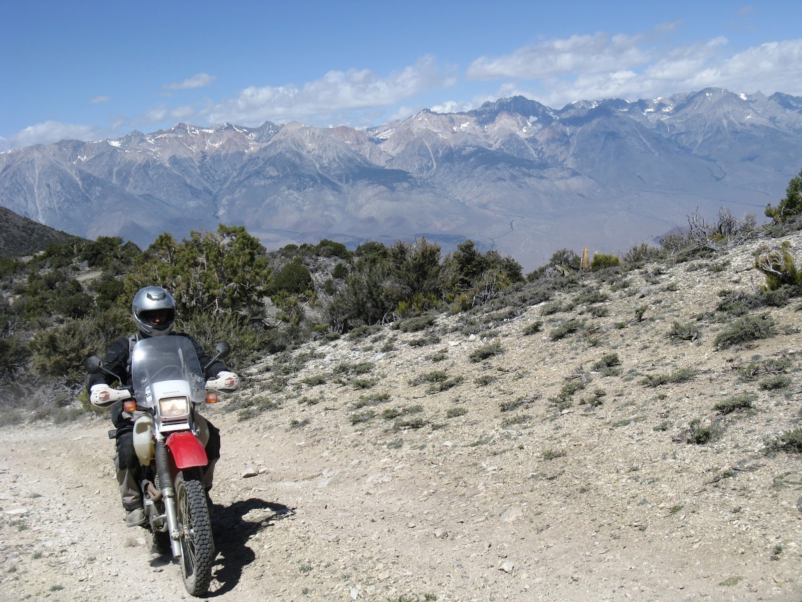
Lake Crowley, Sierra Nevada

Getting Close to Bottom of Ridgeline

From here, I had a blast zipping across Long Valley on the way to Lake Crowley.  Fast, curvy trails with some mild whoops and sand thrown in for fun.  After Crowley, one heads into the hills and woods to the north, with great views of Mount Morrison.  Much of the trail was covered in sharp Obsidian rocks.  I also stopped for lunch in here and had a delicious almond butter and honey bagel.  I must have been pretty hungry, because that sure hit the spot!


Mount Morrison From Long Valley

Somewhere in this area I started noticing a funny sound every time I let off the gas, like a high pitched whooshing noise.  Couldn't figure out what it was until I pulled over and realized my tire was going flat.  Fuck!  I was still a little over 10 miles from the highway, or an easy access area.  I just decided to keep going with the little air that was left in the tire and see if I could make it to the highway.  Then, I could try and change the tube, or call for help.  I was pleasantly surprised that I actually made it!  First, I tried to pump up the tire only to find out my pump was broken too!  There went the option of changing the tube.  I called Rebecca and let her know what was going on.  I noticed what little air was left in the tire seemed to be holding.  I figured, hell, I'm going to hop on the freeway and try and make the 30 miles of road and 5 miles of dirt back to camp.  Sure sounded like a better prospect than wait three hours on the side of the road for Rebecca.  I was pretty sure she would be pretty relieved not to have to come up there too. Once again, to a much greater and even more pleasant surprise, I actually made it back to camp!  My back tire swerved around a bit and the valve stem disappeared up into the rim, with a completely flat tire right as I pulled into camp.  Even though I had no mirrors, a close to flat tire, hugging the side of the road at 50 mph, none of the highway patrol I saw pulled me over, either.  Lucky!

I cracked open a hard-earned beer, or two, enjoyed the views and rambled around the nearby fall colors, while snapping some photos.  It was nice to relax with the great views before starting the drive home


I took some video too, but it turned out pretty disappointing.  The mount was loose and the camera ended up looking down at the ground more than the scenery!  Most of the fall colors and scenery never even made it into the field of view.  Really wish I snapped more photos of the fall colors and even the wild horses I came across, but I thought I was capturing a ton of video, so why bother!  Oh well.  I still managed to put together a half-way decent little clip.


Friday, March 15, 2013

On A Dirtbike With No Name, Death Valley

This blog entry is mainly an excuse to post a video, so I can test out that part of blogsplot's functionality.

This ride was from spring, 2012 and is going to be the first of an annual tradition of long, solo dirt bike rides, if I can help it.  It's hard to describe the liberating feeling one gets from the saddle while looking out at miles and miles of wide open desert to launch off into!

This one was around 400 miles, over 2 days, with one night spent in the back country in Greenwater Valley, near Golden Valley.  The winds were ferocious in Death Valley on the first day.  I felt so bad for the Hell's Gate Century cyclists I saw while going through, as they had to call off the event.  I did that ride the year before and would have felt horrible to have it canceled like that, after all the training.

I got to go through Butte Valley for the first time, which was awesome.  Also, checked out Barker's Ranch for the first time.  This was Charles Manson's last hideout and where the Inyo County Sherrifs finally got him.  There isn't much to see, as the structure burnt down a ways back, just a cement structure and some shacks.  Hard to believe he got there driving a school bus over Mengel Pass from the East side!  More proof he really was insane.


On a Dirtbike With No Name, Death Valley, 2012 from Evan and Rebecca Thomas on Vimeo.